
The road was rough, and it took us many hours to reach the hydro-station. Unexpectedly, we found river Kizigo in full flood although flood marks indicated that the peak had just passed.
No floods—or even medium-flows —had been measured on Kizigo for over 40 years and it was not possible to establish a rating curve with any degree of certainty. Nevertheless, observers had dutifully collected gauge readings, and there exists an almost complete record of daily water levels. It could just not be used. Without a rating curve—which is the relation between water level and discharge—it is not possible to convert these stage levels into discharge. The latter is by far the most relevant parameter for water resources management.
Field observations provide clues
With great difficulty, we managed to conduct a high-quality discharge measurement. Flow exceeded 300 m3/s. But the field visit yielded many other clues:
- Kizigo is an ephemeral river that is dry for large parts of the year
- Kizigo has an entrenched channel—with almost vertical banks at the top of the channel
- There is a narrow floodplain on the right bank, some 40 m in width and covered with large trees and tall grasses; it was inundated during the peak of the flood; flood marks indicated that water levels reached ~1.25 m; the floodplain was dry during the measurement
- Kizigo at the hydro-station is an alluvial river with low sinuosity; dominant bed material is sand
- The left bank is anchored by rock outcroppings and is effectively stable; there were some signs of erosion on the right bank but nothing serious; there is no evidence (e.g. exposed roots or fallen trees) of a widening channel
- Both intake pipes of an old stilling-well on the left bank were clogged with sand; the stilling-well had not been used for many years
- During the measurement, the flow profile was regular and uniform flow conditions occurred; the river was subject to channel control
The conceptual rating model is inferred from the field observations
The hydraulic approach to rating model development is based on the premise that the parameters of the rating curve can be inferred from field observations of channel properties. Discharge measurements then serve to calibrate and finetune the conceptual model.
By combining the field observations with existing information from the 1970-ies, a conceptual rating model was developed with three segments.
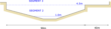
Segment 1: The low-flow channel is probably highly dynamic and will change from season to season. It is therefore difficult to establish this segment. However, this does not really matter since Kizigo is an ephemeral river which is dry for large parts of the year. Hence minimum flow—the parameter needed for environmental flow assessments or permit approval—is zero anyway, while the total volume of discharge in the low-flow channel is minor compared to that in the rest of the channel.
Segment 2: This is where the bulk of Kizigo flows occur. Riverbanks appear stable. The main channel is some 90m in width.
Segment 3: There is not enough information to establish this segment of the rating curve with any degree of certainty. But flood peaks are rare and last only a few hours.
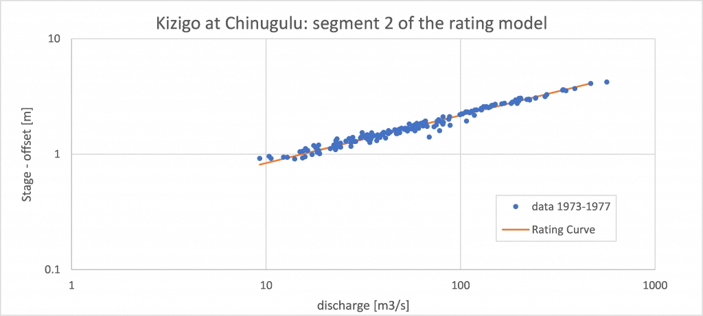
Conceptual rating model calibrated with 1970-1973 data
More than 250 streamflow measurements were made on Kizigo in the five years from 1973 to 1977. Segments 1 and 2 of the conceptual rating model were calibrated using these data.
Update the rating model with current observations
River Kizigo at the control section is subject to gradual bed aggradation—probably because of increasing sediment load due to upstream land-use changes—but its banks appear stable. Field observations indicate that most hydraulic parameters—i.e. flow conditions, bed material, slope, sinuosity, and channel width—are effectively stable. It implies that the parameters of the standard rating equation have likely remained constant apart from the offset.
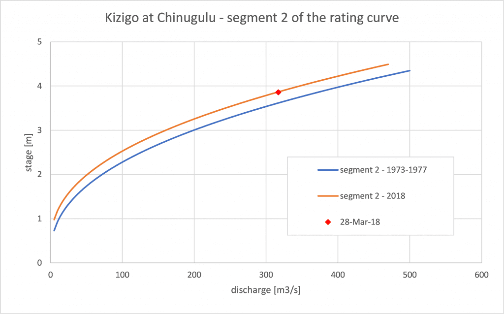
The offset was adjusted based on the high-quality discharge measurement made in March 2018. Hence a plausible rating curve for 2018 was obtained.
Plausible, reasonable, but no hundred percent confidence
Kizigo had not been measured for over 35 years. Nevertheless, the flood measurement in March 2018 was consistent with the 1973-1977 data set. Field observations confirmed that many hydraulic parameters had not changed since the 1970-ies. In addition, a plausible explanation—i.e. gradual bed aggradation—was provided for the observed shift in the stage-discharge relation.
These observations made it possible to infer the rating curve for 2018 with a single precision measurement with a reasonable degree of confidence. Curves for the intermediate period can be interpolated.
It is acknowledged that developing an accurate rating model is not possible without actual data. Nonetheless, the approach presented in this post is plausible & defensible and has enabled the recovery of a long time-series of river discharge with reasonable confidence. If used with appropriate caution, the data set represents very valuable information.
Closing comments
The hydraulic approach to rating model development is a robust conceptual methodology that is based on the hydraulic characteristics of the control section. Field observations of channel properties suggest the shape of the rating model and provide clues for the coefficients of the standard rating equation. Historic and current discharge measurements are then used to validate and calibrate the conceptual rating model. In many cases, only a rather limited number of data points is sufficient to confirm the model. It produces an accurate and defensible rating curve that corresponds with the hydraulics of the river. For more information on this approach, see a previous blog post on this subject (28 October 2020).
Contact Bart Hilhorst (hilhorst@fireflybay.com) if you wish to learn more about the hydraulic approach to rating curve development. He has extensive experience in using the methodology to improve the quality of (historic) discharge time series and optimize field measurement programs.