
Two quotes to set the scene:
It’s an illusion to think you can predict extreme events (Nassim Taleb)
Nobody can predict and therefore one should not try. The only relevant discussions about the future are those where we succeed in shifting from “whether something will happen” to: “what will we do if it happens?” (Arie de Geus, Former Head of Planning, Shell)
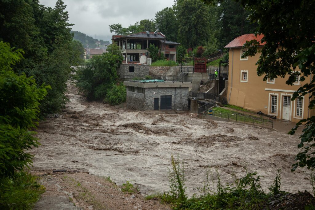
Devastating floods in July 2021 caused unprecedented damage in Germany, Belgium, and the Netherlands. These floods were not anticipated and broke historic records.
The catastrophic floods were primarily caused by local precipitation extremes. This was attributed to more moisture in the air—because of warmer air—in combination with slower moving storms. Indeed, an almost-stationary storm will increase the duration of a rain event, and therefore inevitably lead to more rainfall in a specific location.
While slow-moving rainstorms are still uncommon in Europe, they are expected to occur more frequently in the future because of climate change. In a warming climate, the temperature difference between the poles and the tropics is smaller. This weakens the Jetstream and creates slow-moving storms. It happens specifically in the autumn, when short-duration rainfall extremes are most likely to occur (Kahraman et al, 2021). It is therefore highly probable that the risk of extreme floods in Europe is beyond what was previously expected, and we will need to prepare for this.
I think there is no point to try to quantify this risk. Flood mechanisms are highly complex and involve non-linear processes that are virtually impossible to predict. Instead, let’s focus on the options to mitigate or prevent flood damage. The first step is to have a look at land use in the riparian zone.
Use of the Riparian Zone Evolved as a Function of the Historic River Regime
The riparian zone is a popular area. This is where roads are built because of the gradual longitudinal slope. Settlements and villages concentrate near the roads and river. It is a scenic area where folks like to live. People knew the historic flood levels and stayed clear of areas that could inundate. It was a happy marriage.
But the hydrologic regime has irreversibly changed. The regime of a river is a function of catchment conditions and climate. Catchment conditions that have deteriorated can be restored (in theory). By contrast, the changes in the climate are probably irrevocable (for the next few hundred years), with even more changes ‘already baked into the system’. The precipitation extremes caused by this changing climate will lead to higher floods, which will inundate areas that never flooded before. Land use patterns in the riparian zone evolved as a function of the historic river regime. But with higher floods, many houses, villages, and infrastructure elements such as roads and bridges that used to be safe are now at risk. It has implications beyond public safety. Potential flood damage is very high while the new flood regime also affects property values, insurance rates, and communication lines. Furthermore, the sense of security is lost in this zone. Strong calls for public action are inevitable.
Realities on the Ground
The safest approach to adapt to this amplified hydrologic regime would be to evacuate most of the area vulnerable to floods—“to give it back to the river”. This approach is fool proof but ignores realities on the ground. There are simply too many people living in the zone at risk.
The “Room for the River” approach adopted by The Netherlands is applicable for lower river reaches, which have a large floodplain that is mainly used for agricultural purposes. In the middle and upper reaches of the river, however, there is generally not enough space for this approach—with scattered houses across the valley. Something different is required. It is based on reducing the speed at which water flows through the catchment, in combination with protecting critical areas and infrastructure.
Capture Rainfall and Slow Down Runoff
“reduce the speed at which water flows through the catchment”
Interventions to reduce flood damage will probably include a combination of measures:
- Catchment restoration—to encourage rainfall to infiltrate rather than run off
- Agricultural practices that encourage infiltration of rainfall (e.g.: cover crops or keyline pattern cultivation)
- Swales (or elevated main and farm roads on contour) that capture overland runoff, encourage infiltration, and temporary buffer and slow down runoff
- Micro-scale water harvesting features that capture rainfall and encourage infiltration
- Check dams and leaky weirs—to reduce slope and slow down river flow in creeks and smaller tributaries, and encourage water banking in the adjacent alluvial zone
- Mini/micro/small reservoirs—to capture runoff from direct rainfall and buffer flood peaks
- Restored (or new) wetlands that buffer flood peaks
- Strengthening and heightening embankments—specifically to protect ‘high value assets’ such as villages and critical infrastructure
- Mounts and elevated land for critical infrastructure and (new) houses
- Widening riverbeds in vulnerable areas—to increase the hydraulic capacity of the river (note that this will create problems further downstream)
- Zoning—prohibit new buildings in areas at risk
- Flood early warning system—to give people time to evacuate
Measures will differ per location and are determined by the topography, land use, economic considerations, and “where we are in the watershed”. Nevertheless, it is probable that all flood prevention plans will include more water storage: in a distributed set of small-scale reservoirs (micro, mini, and small). The higher we are in the catchment, the smaller the structures that are required.
Medium or large-scale reservoirs are not considered in this proposition. They are associated with many adverse consequences and generally invite too much resistance.
The Multiple Functions of Distributed Small Scale Storage Reservoirs
The sense of urgency created by the recent floods provides an opportunity. It is likely that water storage features will be established. Although initiated by the need to prevent flood damage in downstream areas, these features can also perform other functions:
- Landscape rehydration
- Drought management
- Maintaining instream flow requirements
- Create and maintain environmental value
- Serve as ‘virtual battery’ and temporarily store energy generated by solar or wind
- Recreation
- Groundwater recharge
Many of these functions are important and worthwhile to pursue. On their own, they often do not justify an investment in expensive infrastructure. But a viable economic proposition may occur when functions are combined. Adapting the flood retention reservoirs to also perform other purposes will probably involve just minor extra costs and makes perfect sense. Hence the flood emergency can provide the impetus to advance other relevant policy objectives, such as promoting green energy, catchment rehydration, and environmental restoration. This opportunity should not be wasted.
And, to come back to the quotes at the top of this post, there is no need to wait for the results of a detailed flood risk assessments for each segment of the river. Remember: “it’s an illusion to think that you can predict extreme events”. Applied common sense will do. These small-scale water storage features will perform well in each scenario.
| Permaculture design rule 8: “Integrate rather than segregate” The premise that each small reservoir should perform multiple functions is a central tenet of the permaculture design philosophy. In addition, each function should be performed by multiple elements, while design elements should be positioned in a manner that creates beneficial relations among them. This cluster is referred to as a ‘beneficial assembly’. The system is more resilient when each function is performed by multiple elements. In addition, the design can be implemented incrementally—step by step. It is easier this way to mobilize the necessary resources (budget) while overall investment costs are also lower if functions are combined. Besides, we can learn from our mistakes (the moto is not “trial & error” but “trial and small error”). Furthermore, smaller elements can blend into the landscape and are less intrusive, and are much easier to maintain. |
REFERENCES:
Kahraman, A., Kendon, E. J., Chan, S. C., & Fowler, H. J. (2021). Quasi-stationary intense rainstorms spread across Europe under climate change. Geophysical Research Letters, 48, e2020GL092361. https://doi.org/10.1029/2020GL092361