I originally trained as a civil engineer but already left this field in the early 1990s—after working as a junior design engineer on the storm surge barrier in Rotterdam harbor: a thoroughly exciting project.
Nevertheless—like so many of us—I have always remained fascinated by hydraulic engineering. The Shabelle Basin Diagnostic rekindled this old passion.
Inverse Topography
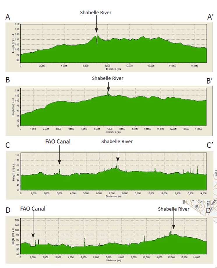
The lower reach of river Shabelle is subject to inverse topography. It means that the channel is above the surrounding land, as illustrated in the below transects. The Shabelle has a very high sediment load and some of this material is deposited in the channel—cm by cm—once the river enters the flat lands upstream of Jowhar, where flow velocities decrease. The channel gradually rises. At some point in time, the river will break out of its banks and find another path at a lower point in the landscape. However, since the sediment load will remain high, also this new channel will over time become the highest point in the landscape, and the cycle continues. It is a long cycle that can take several hundred years.
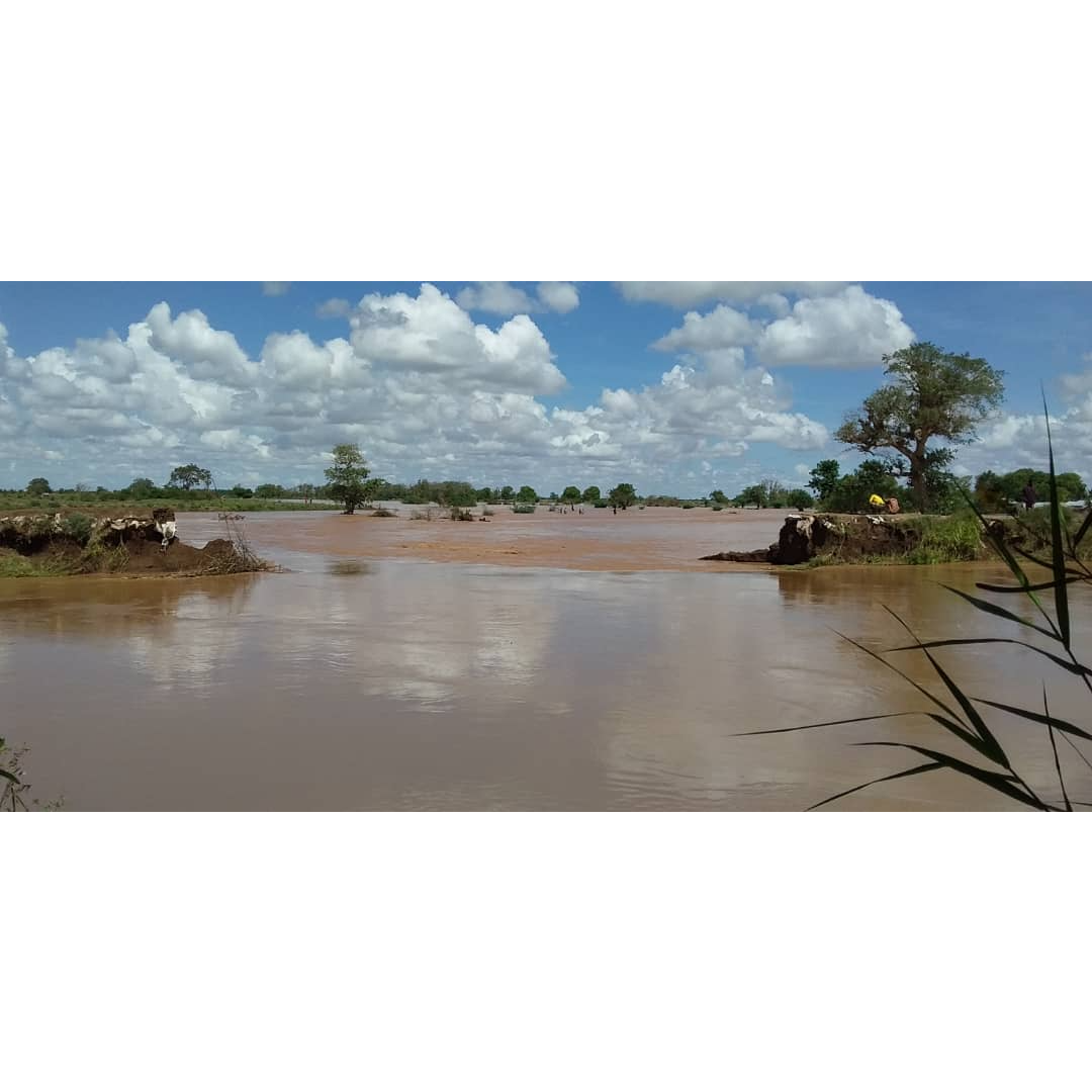
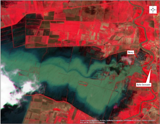
Inverse topography is problematic because it leads to extensive flooding once the river bursts its banks. The below image shows the massive inundations in June 2021 after a breach near the village of Barey. The entire area between two east-west oriented irrigation canals was flooded, causing damage to crops, livestock, infrastructure, and properties, while elevating risks of water-borne diseases.
FAO SWALIM in 2019 identified 39 open gaps in the Shabelle embankments, while there were numerous points that were weak or could overflow during floods. Hence the Shabelle levees are inadequate, to say the least.
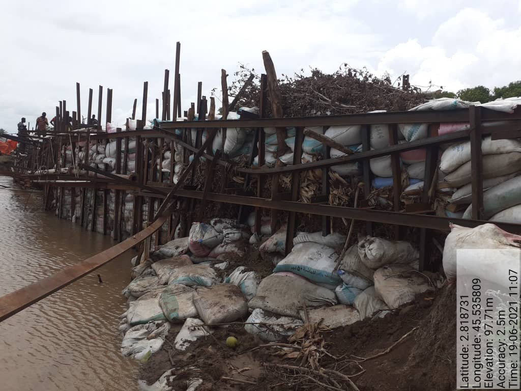
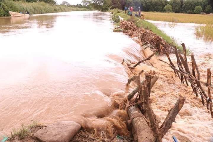
Communities mobilize for obvious reasons once a levee breaks and try to repair the breach. The massive effort made to control flooding is illustrated in the below image. Unfortunately—despite the impressive attempt—this levee was breached again a few weeks later. It points to the tremendous power of water and the need to come up with a durable and robust solution.
Do Not Create a False Sense of Security
One of the recurrent themes on this blog is that the capacity for water resources management (WRM)—in terms of budgets, staff, data, models, infrastructure, etc.—is inadequate in large parts of the world. Given the context of Somalia—with massive investment needs and huge competition for public funds—we should not expect a different situation. Hence the following observations are made:
- There are probably not enough funds to strengthen embankments along the entire river
- Most funding in the short and medium-term future will originate from projects or donor programs and not from permanent government sources
- It is unlikely that adequate funds for maintenance of levees can always be guaranteed; hence there are probably some future time windows with no or insufficient maintenance budgets
Moreover, climate change is expected to increase flood volumes. We do not even know the water levels for which we need to prepare. Thus, the flood defenses that can realistically be established—given the available budgets—will probably not prevent all future inundations.
A feasible objective, therefore, is to prevent expensive flood damage rather than prevent all flooding. In practice it means that (some) overtopping may be tolerated but that breaching of embankments should be avoided under all circumstances.
There are some benefits to this setup. It avoids creating a false sense of security. People know that incidental overtopping and flooding can happen and will prepare for this. The volumes of water involved are a nuisance rather than catastrophic.
The Potential of Geotextile Tubes
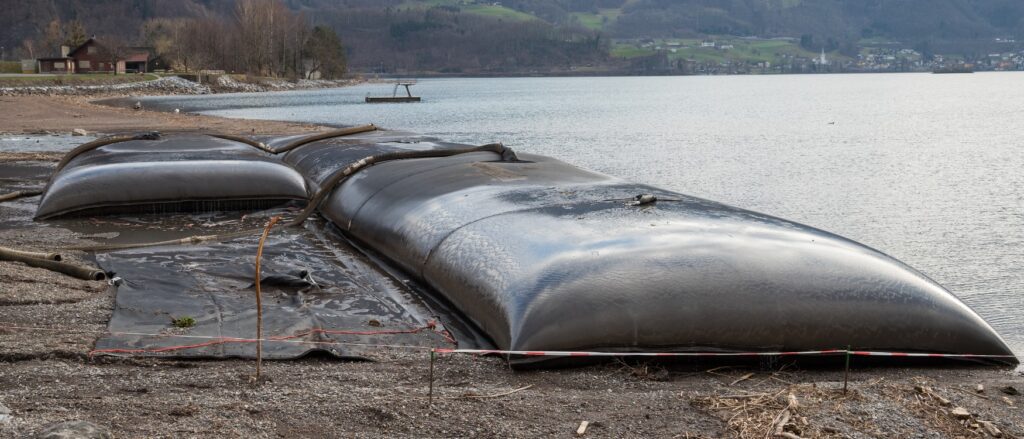
Geotextile tubes are large bags made of permeable geotextiles that are filled with sediment. They typically have a length of some 25 m and a diameter of 1.5 m when used in embankments. The cross-sectional shape is an ellipsoid. The tube-shaped containers are flexible but very strong. The bag keeps the body of sediment in place and prevents incremental erosion of the embankment that would otherwise have led to progressive erosion and eventual collapse. Geotextile tubes are very durable when covered with sand, vegetation, or a woven fabric that prevents exposure to UV radiation. They can be placed in parallel or stacked arrangements as needed.
Geotextile tubes are applicable for the embankments along Shabelle because:
- They are heavy and prevent stability failure and embankment collapse; a 25 m geotextile tube with a diameter of 1.5 m filled with sediment has a weight of over 100 ton; it is unlikely that this monolith can by moved by the Shabelle waters under any realistic flood scenario
- The geotextiles prevent incremental erosion of the embankment—which represents a common failure mechanism of earthen embankments made from locally available soils
- Seepage does not cause failure because the geotextile retains the soil; the geotube is flexible and will adjust its shape in case of minor seepage under the construction
- Incidental overtopping of the embankment will neither damage nor move the geotube
- The geotextile tubes require no maintenance if not willfully destroyed, although it is advised to maintain a cover (e.g. soil or vegetation) to avoid exposure to UV radiation
- Geotextile tubes are constructed onsite with locally available dredge material; the equipment required comprises an excavator, small pontoon, and a concrete pump; the construction is straightforward, and the installation is permanent; in addition, sediment removed from the river will increase the hydraulic capacity of the Shabelle
Hence a geotextile tube solution meets all criteria set for the Shabelle embankments: 1) no maintenance, 2) no or low risk of embankment breakage, and 3) incidental overtopping is tolerated.
Given the fact that hundreds of kilometers of levees along the Shabelle require strengthening, it is worthwhile to explore this practical, robust, durable, cost-effective, and eco-friendly solution.
NOTE: Strengthening of the embankments is just one of the strategies being considered to prevent flooding of the riparian zone along the Shabelle. Other measures being investigated include (re-)creating water storage (such as in the Jowhar Off-stream Storage Reservoir) and rehabilitating the Duduble Flood Relief canal. It is probable that a combination of measures will be implemented in parallel.
Shabelle Series
This post is the third in the series on the Shabelle basin in Somalia. Previous posts were:
- Dryland Restoration—From Evaporation to Transpiration
- Large-Scale Public Gravity Irrigation in Sub-Saharan Africa: Part of the Problem or Part of the Solution?