According to a paper by M. Borga et al (2008), most flood data in river basins smaller than 100 km2 in Europe are collected by means of post-event flood surveys. It surprised me. I was aware that few flood measurements are conducted in Africa—where I work a lot, and where many countries are vast and water resources agencies have limited budgets for field programs—but I did not know this was also the case for many rivers in Europe.
Borga’s observation underscores the importance of a consistent and systematic methodology for post-event flood analysis. In addition, it draws attention to the question: “how can we prepare in advance to improve the accuracy of a post-event flood analysis?”
And could there be a role for citizen-scientists?
These are the topics of this blog post.
Slope-Conveyance Method
Using proxy data to estimate river discharge is referred to as an ‘indirect method’. The most common one is the so-called slope-conveyance method. It is based on the application of the Manning equation.
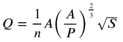
Q = discharge in m3/s
A = cross section in m2
P = wetted perimeter in m
S = longitudinal slope
n = surface roughness as a function on channel material and conditions
While the slope-conveyance method has the advantage of simplicity, it has proven very difficult to accurately measure the longitudinal slope and estimate the surface roughness. Moreover, the Manning equation is based on empirical approximations that may not be valid during flood conditions. Further, quite some river channels are dynamic during extreme floods. The above factors introduce substantial uncertainties in the estimated peak discharge. Gaume (2008) asserts an uncertainty bound of at least 30-50%, which correspond with my own experience.
Can we do better?
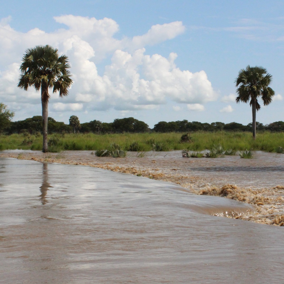
Key is to estimate the flow velocity during the flood. A practical method is to measure the surface velocity of the stream with a floating object and use hydraulic thumb rules to estimate the average velocity for the entire cross section. With the widespread availability of mobile phones, it is no longer imperative to have a hydrologist on site for this measurement. A bystander can film the float or floating debris and the footage is analyzed after the flood. Nevertheless, the uncertainty associated with this type of flood estimate remains high.
A role for citizen-scientists
Some limited pre-event preparations would make this approach much more effective:
- Identify a citizen-scientist who commits to recording occasional flood events on his/her phone
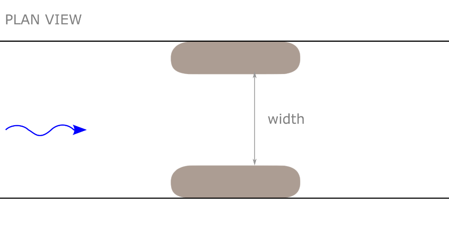
- Select a river reach that that is straight and uniform in cross-section and slope (thus, subject to uniform flow conditions) and preferably without a floodplain; the riverbed should be as stable as possible; the location must have good accessibility
- Identify a safe location from where to film the flood event
- Establish—or select—two markers along the river reach and measure the distance between these markers; the markers—for instance big trees—should be far apart (between 25 and 50 m, depending on the width of the river) so that the travel time of the float can be accurately established
- Place a marker in the middle of the measurement section to provide an extra check on the velocity measurement
- Establish a staff level that can be filmed during the flood event, or identify specific vertical level markers that accurately indicate the water level; when applicable, make sure that you can reference the water level measurement with a nearby hydro station (this can be through a telephone call with the observer at that station)
- Film the water level and film floating debris
- Alternatively, prepare highly visible floats that can be thrown in the river upstream of the first marker; film/conduct at least three float measurements for each flood level
- Measure the cross-section in the middle of the reach before and after the flood event.
Obviously, each site will be different, and the exact preparations will be location specific. Yet the above presents a framework for how to prepare a citizen-science effort that would vastly improve a post-event flood analysis.
It is recognized that the accuracy of the float method is limited by many factors. It is, nevertheless, an improvement over the Slope-Conveyance method and could result in a reasonable estimate of the peak flood if combined with sound hydraulic insights (post-event). In any case, it would be a cost-effective attempt to acquire basic insights into the flood regime of rivers without any flood data. Note that this applies to most rivers.
| On site selection: In some cases, a section suitable for indirect discharge measurement is several kilometers up or downstream of the control section of a hydro-station. Hence tributary inflow—or bank overflow—between the measurement section and the hydro-station can introduce an error. In most cases, however, this is acceptable. The uncertainties associated with the Slope-Conveyance method typically range between 30-50%. This should be much lower for a well-prepared float method. A limited error caused by minor tributary inflow is therefore acceptable, provided the results of the indirect measurements are used with appropriate caution, the measurement is properly described and recorded, and possible tributary inflow is acknowledged. It is obvious that the validity and practicality of the proposed citizen-science approach should be decided on a case-by-case basis. |
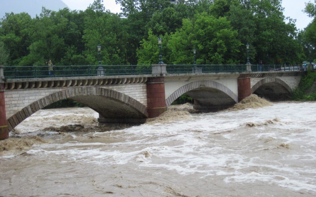
Special Case: Critical Flow Under a Bridge
A bridge—or a culvert—often provides a stable cross-section with a regular and simple shape. The flow area and shape of the cross-section can be measured in advance. Because there is no floodplain, the principal uncertainty for estimating discharge under a bridge is related to assessing mean flow velocity.
In many cases, flow under the bridge remains ‘sub critical’ and we must use the same methodology as described in the above paragraph. However, critical flow conditions may occur during peak flood in case the abutments cause a significant contraction of the river channel.
Discharge, in this case, is independent of channel roughness and only a function of flow area and critical depth. The latter can be recorded during the flood. No floats are needed.
The pre-event preparations include:
- Measure the flow area and shape of the cross-section
- Identify—or create—markers on the abutment to measure the water level during the flood (which are used to calculate the critical depth in the post-event analysis)
- Identify a safe location for the observer—or citizen-scientist—to film/record the flood event on his/her mobile phone.
Post-Event Flood Analysis: Document Every Step
Minor preparations can lead to a significant improvement of a post-event flood analysis and of the resulting flood data. Cooperation with citizen-scientists will make it possible to measure rivers that are not covered by conventional hydrometeorological monitoring networks (for budgetary reasons).
The above two, combined, will increase our insight in the flood regime of the many rivers for which we currently have no flood data.
A closing comment: because it is inevitable that people will question the reliability of the data—and the cooperation with citizen-scientists—it is advised to carefully record and document every step of the indirect method. Not only should we prepare for the post-event flood analysis, but we should also prepare for the expected criticism on the methodology and the skills & dedication of the citizen scientists.
NOTE: Photrack Ltd in Switzerland (formerly iMoMo) has developed a smartphone App (for an Android phone) to measure the surface velocity of an open channel. After the characteristics of the cross-section are added, the App calculates derived discharge. The accuracy of the measurement is quite high for laboratory settings and for small and medium size rivers with a regular cross section. While the App is not free, it is also not expensive (see www.discharge.ch).
It is not clear to me whether the App can accurately measure the surface velocity profile of a river that is experiencing flood conditions, and if there are limitations regarding the width of the river.
REFERENCES
E. Gaume and M. Borga; Post-flood field investigations in upland catchments after major flash floods: proposal of a methodology and illustrations; Journal of Flood Risk Management 1 (2008) 175–189
M Borga, F Comiti, Ruin I, and F Marra; Forensic analysis of flash flood response; WIREs Water (2019); e1338.
Borga, M., Gaume, E., Creutin J.D., & Marchi, L. (2008). Surveying flash flood response: gauging the ungauged extremes. Hydrological Processes, 22(18), 3883–3885. https://doi.org/10.1002/hyp.7111